|
GOD BLESS AMERICA !
Copyright © 2001-2022 Arthur John Huneke
ALL RIGHTS RESERVED
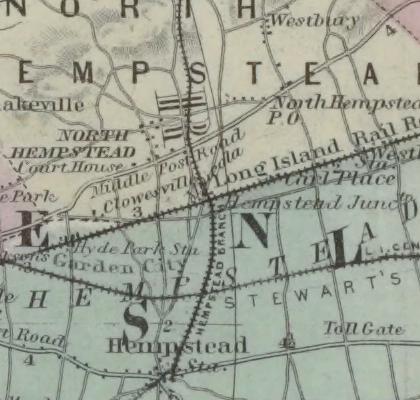
CLOWESVILLE
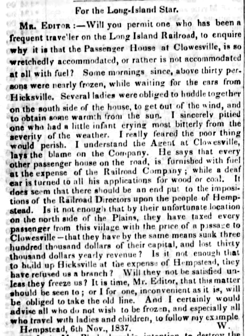
OUR FRIEND BOB RICKEY SENDS THIS 1837 LETTER TO THE EDITOR OF THE LONG ISLAND STAR FROM A RESIDENT OF
HEMPSTEAD WHICH DISCLOSES THAT CLOWESVILLE WAS THE STATION FOR HEMPSTEAD FROM MARCH 1837 UNTIL JULY 1839.
CLOWESVILLE HAD A "PASSENGER HOUSE" AND AN AGENT.
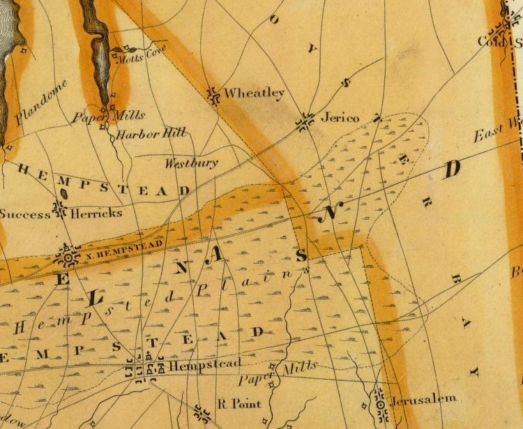
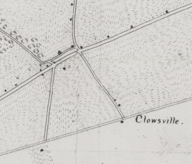
THIS 1829 MAP SHOWS A ROAD RUNNING BETWEEN HEMPSTEAD AND HERRICKS
|
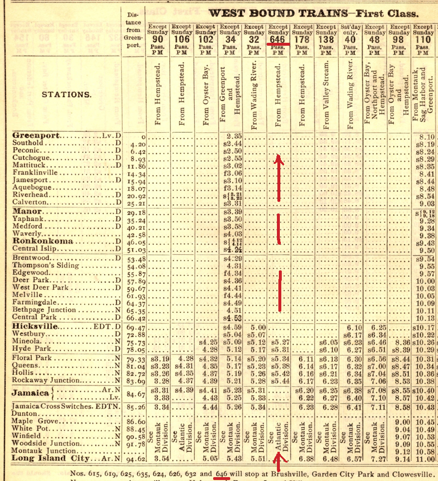
ON MARCH 1, 1837 THE RAILROAD OPENED TO HICKSVILLE BY APRIL 10 1837 CLOWESVILLE  IS LISTED AS A STOP. BY JUNE 1845 CLOWSVILLE (SIC) IS LISTED WITH THIS NOTE: "DURING SESSION OF COURT". THIS IS THE LAST TIME WE SEE CLOWEVILLE LISTED UNTIL EMPLOYE TIME TABLE NUMBER THREE OF JUNE 1897. |

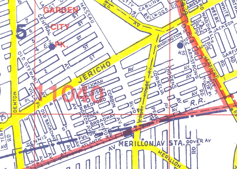
SINCE GARDEN CITY PARK WAS AT THE LOCATION OF
THE LATER MERILLON AVENUE STATION CLOWESVILLE
COULD NOT HAVE BEEN THERE.
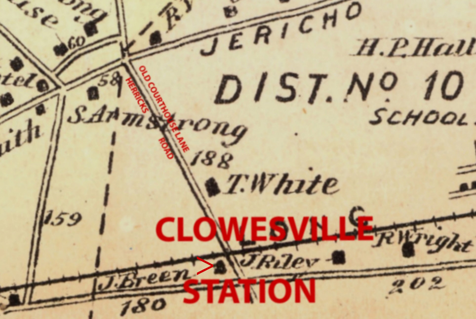
CLOWESVILLE STATION WAS LOCATED AT HERRICKS ROAD.
SUNY STONY BROOK HAS ON THEIR WEBSITE
THIS 1837 MAP WHICH SHOWS CLOWESVILLE THERE
L.I.R.R. CROSSING LISTS FROM 1900, 1908, 1918 AND 1935
IDENTIFY HERRICKS ROAD AS "OLD COURT HOUSE LANE".
THIS LATE 1930'S MAP CALLS IT "OLD COURT HOUSE ROAD".
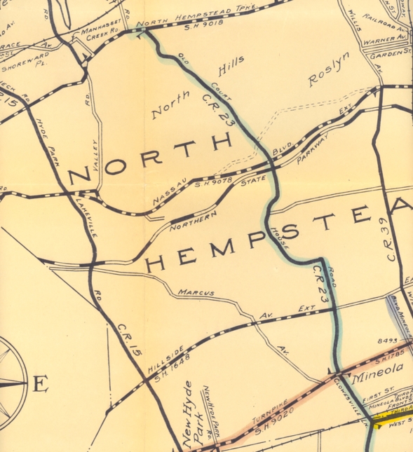
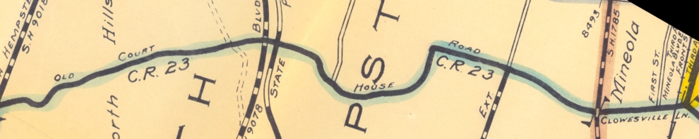
THE SAME MAP CALLS THE SECTION BETWEEN OLD COUNTRY
ROAD AND JERICHO TURNPIKE, "CLOWESVILLE LANE"
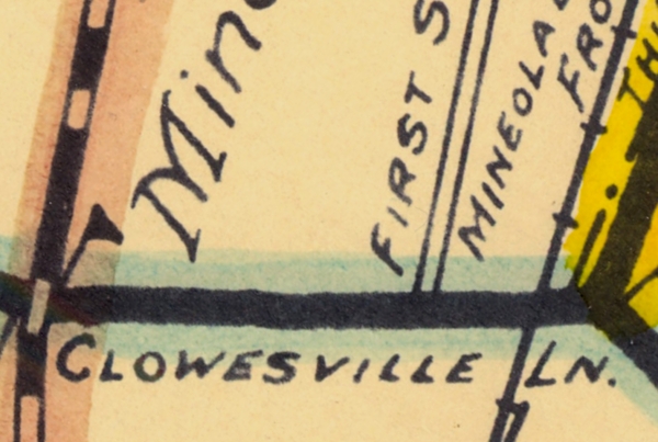
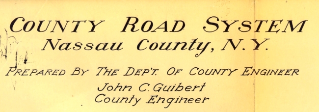
THIS MAP WAS CREATED BY NASSAU COUNTY ENGINEER JOHN GUIBERT.
1873 BEERS ATLAS
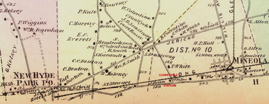
ON THIS 1873 COLTON MAP FROM THE NEW YORK PUBLIC
LIBRARY THE NAME CLOWESVILLE BRACKETS HERRICKS ROAD
WE THANK JAMES G. FAWLES FOR THIS MAP
AND FOR THE FOLLOWING INFORMATION:
THANK YOU JAMES!
RELATIVE TO THE FOLLOWING ARTICLE IS THIS FROM:
HISTORY OF QUEENS COUNTY
with illustrations, Portraits & Sketches of Prominent Families and Individuals.
New York: W.W. Munsell & Co.; 1882.pp. 57-59.
"The practitioners in the inferior courts were residents in the
"county, such as : Samuel Clawes, father and son, 1710-53....."
FROM: THE ROSLYN NEWS
ON LINE EDITION FRIDAY February 20, 2009
What Do You Know About Herricks?
THE FOLLOWING INFORMATION IS FROM VARIOUS SOURCES INCLUDING:
THE ROSLYN NEWS, WIKIPEDIA AND DAVID ROBERTS at BROOKLYN GENEALOGY
FROM AN 1838 REPORT:
THE FORMER COUNTY COURTHOUSE WAS LOCATED NORTHEAST OF THE
INTERSECTION OF JERICHO TURNPIKE AND COUNTY COURTHOUSE ROAD.
HERRICKS ROAD HAD BEEN KNOWN AS "OLD COURT HOUSE LANE".
RETURN TO -----> HOME PAGE
THE LATER MERILLON AVENUE STATION CLOWESVILLE
COULD NOT HAVE BEEN THERE.
CLOWESVILLE STATION WAS LOCATED AT HERRICKS ROAD.
SUNY STONY BROOK HAS ON THEIR WEBSITE
THIS 1837 MAP WHICH SHOWS CLOWESVILLE THERE
L.I.R.R. CROSSING LISTS FROM 1900, 1908, 1918 AND 1935
IDENTIFY HERRICKS ROAD AS "OLD COURT HOUSE LANE".
THIS LATE 1930'S MAP CALLS IT "OLD COURT HOUSE ROAD".
THE SAME MAP CALLS THE SECTION BETWEEN OLD COUNTRY
ROAD AND JERICHO TURNPIKE, "CLOWESVILLE LANE"
THIS MAP WAS CREATED BY NASSAU COUNTY ENGINEER JOHN GUIBERT.
1873 BEERS ATLAS
ON THIS 1873 COLTON MAP FROM THE NEW YORK PUBLIC
LIBRARY THE NAME CLOWESVILLE BRACKETS HERRICKS ROAD
WE THANK JAMES G. FAWLES FOR THIS MAP
AND FOR THE FOLLOWING INFORMATION:
|
Herricks Road is actually a VERY old road from the 1600s which went
from Hempstead to Cow Neck (the Manhasset/Pt.Washington Peninsula),
following the route of Rockaway Avenue from Hempstead to Old Country
Rd, just south of LIRR. Rockaway Avenue was nearly a straight run for
250 years over its entire length until a golf Course in Garden City
forced Rockaway Ave to bend to the west, past present-day Garden City
High School. Along with Roslyn Road (again 1600s: the Hempstead to Hempstead Harbor Road), Rockaway Ave/Herricks Road was the only significant N-S road anywhere near the Court House before the Civil War. Heading North from Old Country Road, Herricks Road immediately passes the LIRR Right-of- Way (and the site you've identified as Clowesville), passes the Court House at North Hempstead approx 1/2 mile north of LIRR, then continued to the community of Herricks, which was centered a bit southeast of today's Herricks High School. From there, you could take the road past Searingtown to Sands Point. |
THANK YOU JAMES!
RELATIVE TO THE FOLLOWING ARTICLE IS THIS FROM:
HISTORY OF QUEENS COUNTY
with illustrations, Portraits & Sketches of Prominent Families and Individuals.
New York: W.W. Munsell & Co.; 1882.pp. 57-59.
"The practitioners in the inferior courts were residents in the
"county, such as : Samuel Clawes, father and son, 1710-53....."
FROM: THE ROSLYN NEWS
ON LINE EDITION FRIDAY February 20, 2009
What Do You Know About Herricks?
|
In 1786, the new county courthouse and seat of government was opened a few hundred feet from what is now the northwest corner of Jericho Turnpike and Herricks Road. The area quickly got nicknamed "Clowesville," most certainly after Samuel Clowes (1722-1800) a high-ranking Queens County judge who purchased a house nearby. To many of the lawyers and others who had to trudge out there for official business, the dingy courthouse seemed to be truly in the middle of nowhere, and the name Clowesville may not have been exactly complimentary (half a century later, there was still just a single tavern and a few inns renting rooms nearby, among the scattered houses). On court days, farmers sold snacks, ales and liquor from booths (drunkenness at court was a longtime problem), and there were occasional fairs and other entertainments. In 1837, the railroad connected Jamaica and Hicksville, and on the days the courts or the Board of Supervisors (the county legislature) were in session, trains would make a Clowesville stop at approximately the location of the present Merillon Avenue Station (the fare from Brooklyn was 37 and one-half cents for many years). A permanent post office was opened in the courthouse, the first in North Hempstead township, and the vicinity was officially referred to as "North Hempstead" or "North Hempstead Post Office." Clowesville was still the common name of this place during the Civil War, but went out of use when the courthouse closed in 1877, probably having lost meaning. |
THE FOLLOWING INFORMATION IS FROM VARIOUS SOURCES INCLUDING:
THE ROSLYN NEWS, WIKIPEDIA AND DAVID ROBERTS at BROOKLYN GENEALOGY
|
A permanent post office was opened in the courthouse, the first in North Hempstead township, and the vicinity was officially referred to as "North Hempstead" or "North Hempstead Post Office." THE ONLY POST OFFICE BETWEEN JAMAICA AND SUFFOLK COUNTY WAS "QUEENS" ESTABLISHED SEPTEMBER 25, 1794. A NEW BUILDING WAS ERECTED ABOUT 1787 IN AN AREA NEAR MINEOLA KNOWN THEN AS "CLOWESVILLE" THIS HISTORIC POST OFFICE HAS HAD A VARIETY OF NAMES. IT WAS OFFICIALLY QUEENS BUT THE AREA WAS KNOWN AS "QUEENS COURT HOUSE". ON MAY 21, 1805 ITS NAME WAS CHANGED TO NORTH HEMPSTEAD . |
FROM AN 1838 REPORT:
THE FORMER COUNTY COURTHOUSE WAS LOCATED NORTHEAST OF THE
INTERSECTION OF JERICHO TURNPIKE AND COUNTY COURTHOUSE ROAD.
HERRICKS ROAD HAD BEEN KNOWN AS "OLD COURT HOUSE LANE".
RETURN TO -----> HOME PAGE